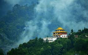
Sikkim is the 22nd state of India came into existence with effect from 26th April, 1975. Sikkim has been divided into four districts and each district has further been bifurcated into two sub-divisions for administrative purpose. Sikkim state being a part of inner mountain ranges of Himalayas, is hilly having varied elevation ranging from 300 to 8540 meters. But the habitable areas are only up to the altitude of 2100 mtrs. Constituting only 20% of the total area of the state. The highest portion of sikkim lies in its north west direction. A large number of mountains having altitudes of about seven thousand meters stands here with - Kanchenjunga (8598 m.), The third highest peak in the world. The high serrated, snow capped spurs and peaks of Kanchenjunga look attractive consisting of Kumbha Karna (7711 m.), Pendem (6706 m.), Narsingh (5825 m.), Kabru Dome (6545 m.), etc. A number of glaciers descends from eastern slopes of Kanchenjunga into Sikkim where snow clad line is found above 5300 mtrs. The biggest of them is Zemu, from whose snout above Lachen monastery rises the river Teesta. Teesta is the main river and its main tributaries are Zemu, Lachung, Rangyong, Dikchu, Rongli, Rangpo and Rangit which form the main channel of drainage from the north to the south. It boasts of the great mount Kanchendzonga as its crown. Ethically Sikkim has mainly three groups of people viz. Nepalis, Bhutias, Lepchas. The local language is Nepali. English is the official language. This jewel- like mountain state of ethereal beauty with an area of 7299 sq. kms , nestles in the heart of Himalayas. Cradled in the manifold splendors of nature deep within the snow clad Himalayas is Sikkim's capital Gangtok. Wrapped in mists and clouds, a garden state with an incredible variety of rhododendrons & a host of other flowers


.png)